Category:Herrengasse 12, Vienna
Jump to navigation
Jump to search
| Object location | | View all coordinates using: OpenStreetMap |
|---|
hotel in Vienna  | |||||
| Upload media | |||||
| Instance of | |||||
|---|---|---|---|---|---|
| Location | Innere Stadt, Vienna, Austria | ||||
| Street address |
| ||||
| Architect | |||||
| Heritage designation | |||||
| official website | |||||
 | |||||
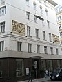
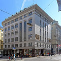
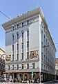
Deutsch: das Haus Herrengasse 12 im 1. Bezirk, in Wien, errichtet als Filialgebäude der Živnostenská banka (Prag)
Media in category "Herrengasse 12, Vienna"
The following 11 files are in this category, out of 11 total.
-
 Haus-Herrengasse 12-01.jpg 1,500 × 2,000; 1.13 MB
-
 Herrengasse 12 Ansicht 1.jpg 2,840 × 2,208; 2.53 MB
-
 Herrengasse 12 Ansicht 2.jpg 3,080 × 2,360; 2.86 MB
-
 Herrengasse 12 Ansicht 3.jpg 5,463 × 5,415; 7.46 MB
-
 Herrengasse 12 Ansicht 4.jpg 3,428 × 4,888; 4.73 MB
-
 Herrengasse 12 relief 01, Vienna.jpg 4,352 × 3,088; 5.37 MB
-
 Herrengasse 12 relief 02, Vienna.jpg 4,175 × 2,893; 4.85 MB
-
 Wien 072 (4428540659).jpg 1,202 × 1,611; 396 KB
-
 Wien kamienica Herreng 12 detal 1.jpg 2,993 × 2,046; 2.97 MB
-
 Wien kamienica Herreng 12 detal 2.jpg 2,888 × 2,125; 3.45 MB
-
 Wien-Innere Stadt - Herrengasse 12 - ehem Zivnostenská banka.jpg 3,010 × 4,516; 6.88 MB


.jpg)


Categories:
- Herrengasse, Vienna
- Leopold-Figl-Gasse, Vienna
- Strauchgasse, Vienna
- Wallnerstraße, Vienna
- Cultural heritage monuments in Innere Stadt, Vienna
- Banks in Vienna
- Former banks in Austria
- Hotels in Vienna
- Art Nouveau architecture in Vienna
- Built in Vienna in 1919
- František Krásný
- Živnostenská banka
- Buildings in Austria numbered 12